Texas has it all, bayous, beaches, canyons, caves, deserts, forests, lakes, mountains, an ocean with 350 miles of coastline, prairies, rivers, and the only-in-Texas Hill Country. Texas’ extremely varied terrain comprises over 800 habitat types. Texas’ habitats support 540 species of birds and migratory birds, and 142 species of mammals, amphibians, and other animals.
Texas is the “Battiest State in the U.S.” Of the 47 species of bats found in the U.S., 32 species hang around in Texas. Alligators, black bears, cougars (mountain lions), and ocelots are the largest animals in Texas. Texas’ black bear and ocelot numbers are at a minimum viable population, if that. Millions of people discover the multitude of Texas’ mesmerizing wildernesses annually on its famous trails.
The Lone Star Hiking Trail
At 96-miles long, the Lone Star Hiking Trail winds through the Sam Houston National Forest. The Sam Houston National Forest is about 50-miles slightly northeast of Houston in Montgomery, San Jacinto, and Walker Counties.
The Sam Houston National Forest is a horseshoe-shaped region where needles of loblolly and shortleaf pine trees crackle under hiking boots. Visitors marvel at pine tree and hardwood tree canopies, magnolia trees, babbling streams, and a few bayous.
Hikers can camp along most of the route except during hunting seasons along this well-marked route. Plus, there are a few developed campgrounds near the trail, with bathroom facilities and opportunities for fishing and canoeing.
Caprock Canyons Trailway, Caprock Canyons State Park
The Caprock Canyons Trailway follows part of the Fort Worth and Denver South Plains Railway, which ceased service in 1989. This 64-mile trailway is home to around one-half-million Mexican free-tailed bats in the 582-foot Clarity Tunnel. It is a rugged and primitive trail with campsites. It is located between Amarillo and Lubbock.
Cyclists, equestrians, and hikers take a backwards time machine trip into Texas Panhandle history on this trail. The trailway is divided into six sections from five to 17-miles long with eight trailheads and two terminals, the South Plains Terminal and the Estelline Terminal. Visitors can spend a day trip or plan a multi-day trip.
Visitors can stay on the trail in primitive campsites or in Caprock Canyons State Park, where there is another gorgeous trail system. The trailway is rated moderate to easy and most popular with mountain bikers. Majestic views of canyons and caprock escarpments greet visitors hungry for a surreal getaway.
Cross Timbers Trail, Lake Texoma
Come hike, bike, kayak, and/or camp on the Cross Timbers Hiking Trail at Lake Texoma near Gordonville, Texas. This trail runs near the shoreline around a small bay of western Lake Texoma. With abundant wildlife and a natural trail, you will find an amazing adventure.
There are primitive campsites on this 14-mile trail. It is rated moderate to strenuous and can accommodate mountain bikes. Cross Timbers begins at the Juniper Point West Campground at the Willis Bridge on SH 377 and ends at Rock Creek Camp. Hikers need to be aware of snakes, coyotes, and a rare bobcat sighting.
Cross Timbers leads hikers over rocky ledges to Lost Camp and Cedar Bayou Marina. Along the trail, the primitive campsites are Lost Camp on the Lost Creek loop, 5-Mile Camp, and Eagle’s Roost. You can find nearby Airbnbs, cabins, and kayaks to rent, a store with supplies and a microwave oven at Cedar Bayou Marina, and on US 377.
From there, the trail heads south to 5 Mile Camp, which is the most challenging part of the trail. Hikers need to arrange for a ride back to their starting point or plan at least a three-day out and back hike. Very few people hike this trail in one day. You pay for parking at the trailheads at Juniper Point West, Cedar Bayou Marina, and Rock Creek.
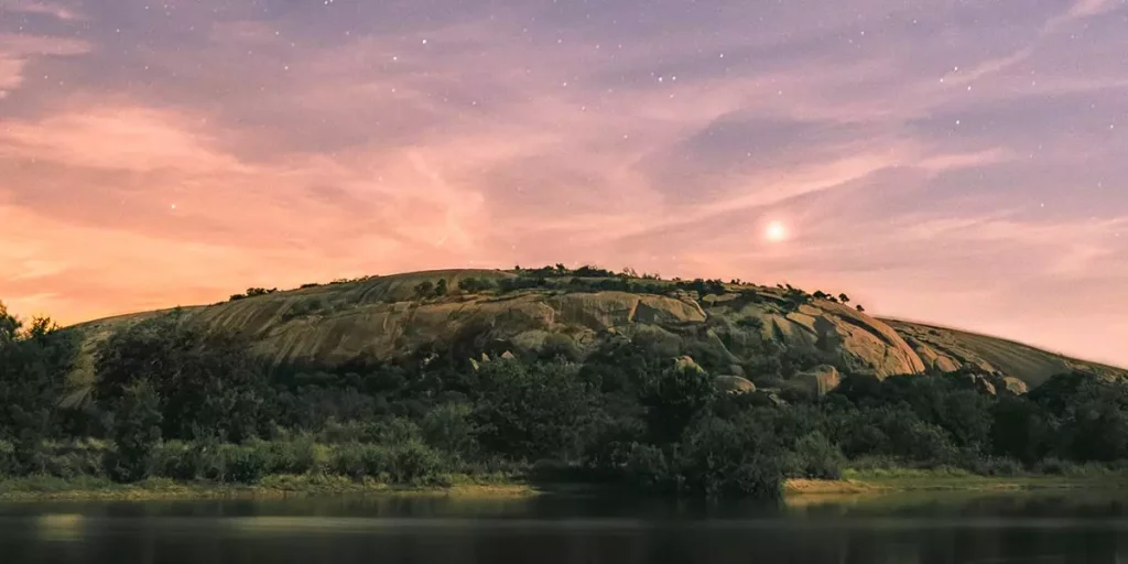
Enchanted Rock Summit Trail, Enchanted Rock State Natural Area
The Enchanted Rock State Natural Area (ERSNA) near Fredericksburg is one of the most popular parks in Texas. The Enchanted Rock State Summit Trail, while short at 1.5 miles, is rated moderately strenuous and takes an average of two hours to complete. Wildflowers bloom in April and render a beautiful experience in early mornings and late afternoons.
Junior rangers and volunteer guides lead hikes, telling tales of biology, history, and geology with incredible views. Or, you can hike on your own. Reservations are required to enter Enchanted Rock on weekends, holidays, and/or during school breaks. You can check day pass availability and make reservations online at TexasStateParks.ReserveAmerica.com.
Additionally, the ERSNA offers a total of 8.4-miles of hiking trails. This park fills up quickly and limits occupancy. The Summit Trail winds to the top of Enchanted Rock with rare vernal pools at the top. The pools are home to the delicate fairy shrimp and rock quillwort, so please do not disturb these fragile habitats.
Gorman Falls Trail, Colorado Bend State Park
The Colorado River wilderness at this bend greets visitors about two hours northwest of Austin and not too far north of Buchanan Lake as the crow flies, but an hour’s drive from Tow, Texas. In the magnificent Hill Country, cascades the imperial and living 70-foot Gorman Falls.
The Gorman Falls Trail, embedded with limestone and rock, meanders through Ashe juniper (cedar) trees, native grasses, and prickly pear cacti, and then slopes downward to dense woods, where the sound of surging water meets the ear. The final descent enters a deep canyon with breathtaking views.
Gorman Falls was 65-feet tall in 2013, but it is 70-feet in 2024. It is a living waterfall because most waterfalls erode their substrates. Gorman Falls collects and builds up minerals like calcium carbonate from the springs that feed it, and it constantly grows.
Its travertine formations look like moss-covered stalagmites. Beware of travertine’s rock-like appearance. The park roped off the falls to protect their fragile composition. Stepping on travertine is like stepping on thin panes of glass. The 1.5-mile Gorman Falls Trail to the waterfalls and back is rated moderate until the final descent, with slippery rocks, but there are cable handrails to help.

Guadalupe Peak Trail, Guadalupe Mountains National Park
If you are a skilled outdoor hiker with expert survival skills, you can reach the apex of Guadalupe Peak for a vista that rewards you with a 200-mile radius of miles and miles of Texas. The strenuous 8.4-mile out and back Guadalupe Peak Trail gains an elevation of 3,000 feet.
Guadalupe Peak is called the “Top of Texas”. At 8,751 feet above sea level, it is the highest mountain and natural point in Texas. You cannot see the peak from the trail, which does not come into view until you are almost at its summit. Oxygen thins as you ascend to the summit.
The Guadalupe Mountains National Park is your hub for all information, including fees, laws and rules, requirements, and safety precautions at the Pine Springs Visitors Center. Visitors can access this visitor center via US 62/US 180 between Carlsbad, New Mexico, and El Paso, Texas.
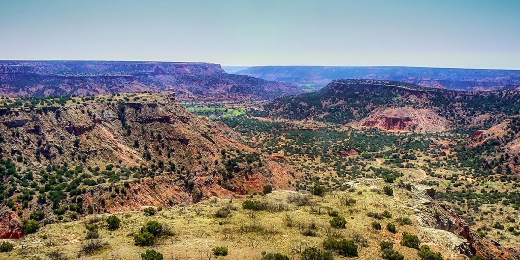
Lighthouse Trail, Palo Duro Canyon State Park
Palo Duro Canyon’s Lighthouse is the beacon of the Texas Panhandle. Its alluring hypnotic “Lighthouse” is a creation of natural forces, which carved this sandstone pillar. The Lighthouse Trail is the most popular trail and off of an extensive trail system in Palo Duro Canyon State Park.
Palo Duro Canyon State Park lies about 30 miles southeast of Amarillo and 12 miles directly east of Canyon. The Lighthouse Trail is a 5.5-mile out and back climb of 176.5 feet on a sandy dirt path with loose rocks and steep slopes. The trail ranges from easy to strenuous skill levels.
Even in April, this trail is very hot. Natural elements painted the Palo Duro Canyon region in vivid hues of ambers, lavenders, and reds. This well-marked trail accommodates hikers and mountain bikes. It begins on the canyon floor and carries you up to the rim with majestic views.
River Place Nature Trail, Austin
The River Place Nature Trail is one of the most popular trails near Austin. This trail is 5.5-miles long, rated as strenuous, and has over 5,000 steps to assist hikers up and down its path. The rest of this trail is hard-pack soil and rock. Hikers cannot tell that they are so close to the Texas State Capitol on this tranquil nature hike. It lies between the Colorado River and Lake Travis.
Panther Hollow, Canyon, and Little Fern Trails are the three trails of the River Place Trail system. It meanders over small bridges around serene pools of water, waterfalls, rock ledges, and canyon walls. The River Place Municipal Utility District manages it.
Three trailheads are located off of Big View Drive. The trailhead off of Big View Drive across from the tennis courts and soccer fields features a kiosk detailing the trail route and animals that reside in the trail’s habitats. Bicycles are not allowed.
South Rim Trail, Big Bend National Park
The two segments of the South Rim Trail, the Southwest Rim at 2.5 miles and the Southeast Rim at 3.3 miles, are divided by the Boot Canyon Trail at 2.8 miles and among the Big Bend National Park’s 79 trails. The Southeast Rim contains a portion of trail also called the Northeast Rim. South Rim hikers can view almost the entire southern half of Big Bend and Mexico.
This strenuous hike in the Chisos Mountains gains an elevation of 2,000 feet of the total 12.6 miles. Fires and smoking are prohibited in the Chisos Mountains. The easiest trailhead begins at the Chisos Mountain Lodge parking lot. A large wooden sign shows the routes with arrows pointing towards the various trails.
It is difficult to hike the entire trail in one day, but possible, which drains the physicality of the human body while magnifying in the mind to never leave. Metallic signs throughout the trail mark directions, and the “4way” sign points the way to major trails at that junction.
The South Rim Trail comprises switchbacks, lookouts at Ridgetop, Blue Creek, the Big Drop, and the Boot Rock spire. Be extremely cautious at the Big Drop, a ledge that overlooks a vertical drop to the desert floor far below. The drop is so steep that people can literally fall to their death if they get too close.
Wolf Mountain Trail, Pedernales Falls State Park
The Pedernales Falls State Park is 42-miles east of Austin and one of the smaller Texas State Parks. This 5.5-mile loop trail is rated moderate and heavily trafficked. It has little to no shade and accommodates mountain bikes and hikers.
Wolf Mountain Trail is part of a larger trail system that includes seven other trails that range from 0.5 to 11.4 miles and two equestrian trails in Perdernales Falls. Streams wind through these trails and there are overlooks of the Perdernales Falls and Perdernales River.
The Pedernales Falls State Park is one of the most interesting regions of the Hill Country. Along this trail system, visitors will find the Star Theater/Bird Blind for birds by day and star-strewn skies by night. Other points of interest are the Twin Falls Overlook, and Jones Spring.
Notes on Safety Precautions
Some of these trails have no amenities or water, are far away from supplies, range from easy to strenuous, require survival skills knowledge, and are home to wild animals. Some of them are in bear country, and you must store anything a bear can eat and smell, even soap. Wild animal attacks on humans are rare or nonexistent.
The “Leave No Trace” policy is in place. Check with the Texas Parks & Wildlife Department (TPWD) or the National Park Service (NPS) nearest to the trail you choose for fees, laws, rules, appropriate and necessary gear, outdoor wear, and skills information.
Author: Kendall Davis
Author: Kendall Davis Company: Lumini Services Kendall currently lives on the shores of Lake Texoma in Texas. She traveled across two-thirds of the U.S. for many years camping at lakes, rivers, and three oceans before motels and hotels if at all possible, and she continuously saw God's presence in nature. Writing for Lakehub allows Kendall to share her experience with God's creations. https://kdavis1836.wixsite.com/luminiwrites