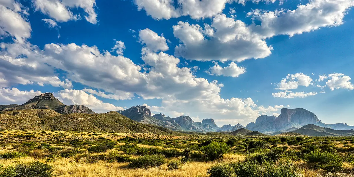
Nestled along the northeast border of the Rio Grande River in far West Texas, Big Bend National Park is a heart-stirring testament to the untamed beauty of West Texas. Stretched across 801,163 acres of vast wilderness, this national sanctuary comprises multiple landscapes from the towering Chisos Mountains to its part of the lush Rio Grande River valley.
Unparalleled grandeur greets humankind, where a rich tapestry of wild life flourishes in the harshest world of the most beautiful forces of nature. Rocky slopes meet vast mesas full of gorges that drift down to desert floors and the sinuous escarpments guarding the Rio Grande River. Vast, star-saturated night skies bring on a bigger than life phenomenon that science cannot explain.
Texas Outside is highlighting 20 of the most popular activities, landmarks, and scenic points in Big Bend National Park. It is impossible to see the entire park in a short time. In 2021, 581,220 visitors experienced amazing adventures in Big Bend. The National Park service recommends spending at least three days in this West Texas park. First, a few Big Bend facts.
Big Bend National Park Facts
History of the Park
This significant national treasure of a park comprises the most archetypal representation of the Chihuahuan Desert ecosystem in the United States. The Big Bend region has witnessed 12,000 years of human occupation by Paleo-Indian, archaic peoples, and several southwestern tribes, primarily the Apache, Chisos, Comanche. Jumano, and Mescalero tribes—until cattle ranchers moved in circa 1870.
Management and Operations
- National Park Service
- Superintendent: Chad Tinney (2024)
- 83 permanent employees
- 26 seasonal employees
- Volunteers in Parks
Dedicated Volunteers contribute thousands of hours to Big Bend National Park each year.
- Aramark (concessioner)
- 32 permanent employees
- 39 seasonal employees
- Big Bend Natural History Association
- 4 permanent / 2 seasonal employees
A non-profit organization that supports education, research and other programs for the benefit of Big Bend. The sales of interpretive products provide financial aid to the park. Outlets for these products are located in all park visitor centers.
- Big Bend Conservancy
A non-profit organization whose mission is to support, promote, and raise funds for Big Bend National Park in partnership with the National Park Service and other supporters who value the unique qualities found in the Big Bend of the Rio Grande.
Big Bend Flora and Fauna
Big Bend is one of the most biologically diverse arid regions in the world and contains the Chalk, Chisos, Christmas, and Rosillos Mountain Ranges.
- 1,295 species of plants
- 75 species of mammals
- 450+ species of birds
- 3,600 species of insects
- 56 species of reptiles
- 11 species of amphibians
- 38 species of fish
Rio Grande River
- 196 miles of Rio Grande River with River Canyons
- Santa Elena Canyon, 20 miles
- Mariscal Canyon, 10 miles
- Boquillas Canyon, 33 miles
- 118 miles Shared Border w/Mexico on the Rio Grande River
- Elevation
- Highest Point: Emory Peak, 7,832 feet
- Lowest Point: Rio Grande Village, 1,850 feet
Major Resource Issues
- Air Quality/Visibility
- Exotic Species/Trespass Livestock
- Rio Grande Water Quality & Quantity
- Theft of Park Resources
Cataloged Museum Objects
413,807
Archeological Resources
Nearly 2,340 sites (8% of park surveyed to date)
National Register of Historic Places
National Register of Historic Places sites or districts in Big Bend National Park:
- Burro Mesa Archeological District
- Castolon Historic District
- Hot Springs Historic District
- The Mariscal Mining District
- Homer Wilson Blue Creek Ranch Site
- Rancho Estelle
- Daniel’s Farmhouse
- Luna’s Jacal
Big Bend National Park Bucket List
Beware: Camping, hiking, and exploring the Big Bend National Park and the Rio Grande River require knowledge of survival skills and water safety skills. You need the proper supplies and outdoor wear. There is no cell service, and if by chance there is, your phone may automatically switch to Mountain Time. Your phone’s compass may not work. Do not depend on electronics in Big Bend.
- Dogs and other pets are not allowed on any trails in the park.
- Let someone know where you are going and when you expect to return. Preferably, do not hike alone.
- Big Bend is mountain lion and black bear country. Keep children close to you; do not let them hike alone or run ahead of the group. If you see a mountain lion, do not run.
- Carry 1 liter of water per person per hour that you plan to hike. The importance of carrying enough water in this hot, dry climate cannot be underestimated.
- Eat plenty of salty snacks to keep your body’s salt-to-water ratio in balance.
- Use sunscreen and wear a hat.
- Many hikers choose lightweight, breathable clothing which covers their arms and legs to protect themselves from the sun.
- Maintain a safe distance between yourself and all wildlife. Animals in the park are wild and should never be approached, harassed, or fed.
- Adhere to the “Leave no Trace” policy.
Visiting Mexico from Big Bend National Park
- US citizens must have a valid US Passport, or a Passport/Crossing card.
- International travelers must have a valid passport and be registered with the ESTA Visa Waiver Program.
- Documentation must be presented to Mexican immigration officials both upon arrival and departure from Boquillas.
- Upon return to the US, documentation is scanned and transmitted to the US immigration office in El Paso, where an official views the document remotely as well as the person presenting. Via a telephone connection, the official asks the standard questions:
- What was the purpose of your trip?
- What are you bringing back? Please note that visitors may not bring back food products, alcoholic beverages, or anything made from animals or parts of animals.
- Big Bend National Park staff are on site to help with the re-entry process and give out information.
What to Expect:
- There is a row boat with a trained oarsman that is available for crossing the Rio Grande. The cost is $5 round trip. Tickets can be purchased at Rio Grande Village Store, or directly from a Boquillas Internationally Ferry representative upon landing in Mexico.
- When the river is low, some people choose to wade the river, which they do at their own risk. The fees generated by the ferry contribute to the livelihood of the ten people involved in the operation and their families.
- The landing is still approximately one mile from Boquillos. Some people choose to walk, and a local guide will accompany you for a gratuity. This is a requirement of the managers of the Federally Protected Natural Area, Maderas del Carmen.
- More popular is the choice to take a horse of burro into town. Horses run $8 per person round trip, and burros $5. A local guide will accompany you, show you the town, and stay close until you are ready to return. Gratuities for good service are always appreciated.
- Visitors may also ride in a pickup for $5 per head.
Boquillas del Carmen
The charming Mexican village of Boquillas where local town folk display handicrafts from their homes, like wire sculptures of lizards, ocotillos, road runners, scorpions and also quilts and embroidered textiles.
Enjoy a meal at one of the two local restaurants. Jose Falcon’s restaurant is a mainstay of the local tourism business. Across the street is Boquillas restaurant, also operated by the Falcon family. The food in both places is simple, fresh, and good.
Castolon Historic District
The Castolon Historic District portrays complex modern human history on the Rio Grande in Big Bend. The cultures of Indigenous Peoples, Spain, and then Mexico, and the U.S. meshed together in one rural community on the border through a few centuries. Its people survived a harsh existence. Anglo-American settlers learned the survival methods of yore.
The resulting Hispanic cross-cultural melding of Spanish, Indigenous Peoples, and North Americans is a multicultural environment today. The buildings at Castolon are a display of Big Bend’s pioneer and military history.
The Mexican Revolution of 1910 attracted bandeleros from Mexico, who raided small border communities and forced people on both sides of the Rio Grande to flee their lands. The U.S. deployed thousands of soldiers throughout the Big Bend area.
The Mexican Revolution ended in late 1920 and the army left. The National Park Service consults with Adobe experts, historic architects, and structural engineers to determine whether these structures can be salvaged or rehabilitated within the Castolon District. The historic Garlick House houses a visitor center.
Chisos Mountains
The heart of Big Bend National Park, the Chisos Mountains, extends twenty miles from Punta de la Sierra in the southwest to Panther Junction in the northeast. It is the only mountain range wholly contained within a single U.S. National Park.
The highest peaks in the Chisos range are:
- Emory Peak: 7,835 feet above sea level
- Lost Mine Peak: 7,535 feet
- Toll Mountain: 7,415 feet
- Casa Grande Peak: 7,325 feet
A 7-mile long paved road ascends into the Chisos Mountain Basin, where craggy peaks encircle a valley. In the Basin, visitors will find a developed National Park Service campground and park, ranger station, interpretive information, maps, the Chisos Basin Trailhead, and can reserve a backcountry campsite, and buy backcountry permits.
Long wilderness trips start in the Basin and connect with trails that extend into the rest of the Park. The Chisos Mountains Lodge operates the only hotel in the park and features a dining room with a grand view. A few rustic stone cabins are available and very much in demand. Its extensive network of hiking trails range from half-mile strolls to round trips that are 5- to 14-miles in length. Day hikers do not need permits.
Chisos Basin Trailhead
This trailhead is near the Chisos Basin parking lot. This well-marked 1.9-mile trail follows various dirt paths. The Chisos Basin Trail is a loop with spectacular views. Other trails from the lodge connect and include Pinnacles Trail to Emory Peak Trail, Boot Canyon, Juniper Canyon Trail, and Northeast Rim Laguna Meadow Trail to South Rim and Blue Creek Trail.
Chisos Basin Visitor Center
The Chisos Basin Visitor Center features interactive exhibits on animals, birds, and plants native to the Chisos Mountains. It issues backcountry and river use permits during normal business hours, and visitors can pay entrance fees. It houses a Big Bend Natural History Association bookstore and restrooms. Visitors can fill personal water containers at a water faucet available on the east side of the building.
Emory Peak and Emory Peak Trail
Emory Peak is the highest mountain in Big Bend. The 4.5-mile hike up is extremely challenging to reach the apex. Hikers report that the views are unbeatable! A 360° panorama on the summit encompasses a vast area of Chihuahuan Desert lands across the national park and as far south into Mexico.
The hike to the top of Emory Peak involves a strenuous climb of about 2,500 feet along a dirt and rock trail. The last 25 feet requires a climb up solid rock without rope, rails, or other artificial handholds. You should not attempt the last mile of this hike when thunderstorms are threatening, especially during the monsoon months of July, August, and September.
- Roundtrip Distance: 10.5 miles
- Elevation Change: 2,500 feet
Fossil Discovery Exhibit
Visitors can experience the changes to Big Bend’s plants and animals, and the world they lived in, through 130 million years of geologic time at the Fossil Discovery Exhibit specimens from Big Bend’s impressive and significant archeological fossil record. This exhibit displays eye-catching artwork of Big Bend’s fascinating ancient life. Its short trail leads to a panoramic view of nearby geological points of interest and highlights the sediments that protect Big Bend’s fossils.
Homer Wilson Ranch
The Homer Wilson Ranch, or the Blue Creek Ranch, was one of the largest ranches in the 1900s, spanning over 28,000 acres. The State of Texas acquired the Oak Canyon-Blue Creek Ranch for incorporation into the new park in 1942.
A large portion of the ranch comprised portions of the old G4 Ranch established in the 1880s. Wilson’s ranch raised and bred sheep and goats, the first such large operation in the Big Bend area. Wilson lived at the ranch until his death in 1943, and his family moved from the ranch the next year.
Lost Mine Trail
The Lost Mine Trail leads hikers into a woodland/grassland ecosystem with some of the best scenic views in the park. Staff and visitors list this trail as their favorite hike in Big Bend National Park. The Lost Mine Trail rises 1,100 feet over 2.4 miles. Its 4.8-mile round-trip offers breathtaking views of the mountains encircling and desert.
Mariscal Mine
The Mariscal Mine provides a glimpse of Big Bend’s history and was once a bustling hub of the Big Bend quicksilver (mercury) mining economy. It operated from 1900 to 1943 and produced 1,400 seventy-six pound flasks of mercury, nearly a quarter of the nation’s output. Abandoned now, it provided income, community, and homes.
A visit to the mine’s remnants evokes images of miners and machinery in a dangerous work environment. Farmer Martin Solis’s discovery of cinnabar in 1900 initiated the mine’s history, and future ownership changes were influenced by WWI’s demands for mercury. Remnants of structures from the early mercury processing phase are visible at the lowest mine level.
Mule Ears Overlook
When you reach the Mule Ears Peaks, which resemble mule’s ears, before you will lay a landscape that blends the violence of the desert’s allure. The ears are two unique eroded rhyolite dikes. The valley floor reveals deposits of white volcanic tuff and lava tops the mountains.
The overlook is a 0.5 mile drive off Ross Maxwell Scenic Drive. Twenty-one pull-in parking places are available and a curb ramp and sidewalk make the overlook wheelchair accessible.
Panther Junction Visitor Center
The best place to begin your visit to begin your Big Bend adventure is via the Panther Junction Visitor Center. Rangers are on site. It issues backcountry and river use permits, and visitors can pay entrance fees. Visitors can fill personal water containers at a water faucet available on the east side of the building.
Exhibits include a theater with a park orientation movie shown upon request, an overview of Big Bend’s geological, natural, and cultural histories, a Big Bend Natural History Association bookstore, a U.S. Post Office, and restrooms.
Persimmon Gap
Persimmon Gap takes its name from the Texas persimmon trees flourishing in this ancient mountain pass. A mountain and line of cliffs stand out against a low desert landscape. Nearly 300 million years ago, this region was part of a monumental mountain range. Around 150 million years ago, a vast sea blanketed today’s hills with layers of sediment when it drew back. Amidst the hills, this ancient rock is exposed, marking the oldest geological formation within the park.
Rio Grande Village Nature Trail
This trail offers a picture-perfect opportunity for birdwatchers and photographers. The sun arises with birdsong and animal life. The late evenings showcase the colors of a great Big Bend sunset. The trail showcases riparian plants and animals over a wheelchair-accessible boardwalk above a small pond.
The trail leads to a small ridge that has a 360-degree view of the Rio Grande, the Sierra del Carmens in Mexico, and the Chisos Mountains. Then it turns into a difficult climb of dirt and gravel with a challenging ascent over a small hill of wooden logs for steps There is parking for four cars.
- Roundtrip Distance: 0.75 mile loop
- Elevation Change: 200 feet
Sam Nail Ranch and Trail
Sam Nail built a two-room adobe house on the banks of Cottonwood Creek in Big Bend in 1916. He married and raised his family there. Visitors can explore remains of their original house, sit in their orchard, and imagine the clucking from their dilapidated chicken coop.
Their wooden windmill pumped water to a tank on the top of Burro Mesa for their cattle. A windmill still pumps water to the surface on their property today for hikers. This rocky, dirt, 0.5-mile loop trail easily descends from the parking lot to the windmill with steps on the north and south end of the trail.
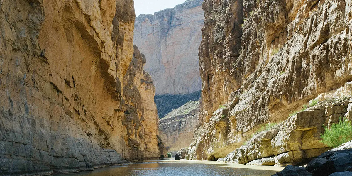
Santa Elena Canyon Trail
This trail begins at the end of Ross Maxwell Scenic Drive. It is revered as a most scenic short hike. Access involves crossing Terlingua Creek’s bed and ascending a short, steep bank. Conditions vary, but as the trail enters the canyon mouth, concrete steps ascend to a vista. It gradually descends winding among boulders to the river’s edge.
It abruptly ends at the narrowest point of Santa Elena Canyon. Listen for canyon wren or the call of the raven along the high canyon walls. Flooding can render the trail impassable during the summer rainy season. Check with park staff for current conditions and know when to avoid crossing if conditions are unsafe. A paved parking lot at the trailhead accommodates approximately 20 vehicles.
Sotol Vista
The site at the western side of Big Bend National Park that sprawls before you is Sotol Vista. Sunrise or sunset is the perfect time to visit and nights bring out star-studded skies. A paved loop road gives access. Ten pull-in parking spaces, three RV spots, and two handicapped parking spots accommodate most vehicles.
South Rim Trail
This trail can be one big day hike or a two-day backpacking trip. Hikers have to take other trails to reach it. The two parts of the trail, the Southwest Rim and the Southeast are divided by the Boot Canyon Trail. If you hike this loop counter-clockwise, it is a gradual climb up to the South Rim on the Laguna Meadows Trail.
If you hike it in a clockwise direction, the climb is shorter but steeper. Stunning views await hikers with a dramatic cliff lookout point as you view the rippling Chihuahuan Desert terrain.
- Distance: 12.6 mile loop
- Total Ascent: 2,800 feet
- Difficulty: Strenuous
- Length of Time: 6 to 8 hours
Tuff Canyon Overlook
Tuff Canyon with the Chisos Mountains in the distance showcases the turbulent volcanic past of Big Bend. Blue Creek, fed by rains rolling from the distant Chisos Mountains for eons, carved this magnificent canyon through layers of volcanic tuff and basalt. Ash and particles ejected from a nearby volcanic vent and accumulated there while still glowing hot 30 million years ago.
Heat and pressure welded the layers of light ash into a material called tuff. Tuff Canyon’s three overlooks offer unimaginable views into the canyon. Two short pathways lead out to three viewing platforms and allow for safe viewing. You are on a canyon rim. Stay back from the edges while up on top because the tuff is soft and easily crumbles.
- A paved pullout at the trailhead provides parking for about 6 vehicles.
- Be careful…steep drop offs exist along the canyon edge. Stay on the observation platforms.
- Tuff Canyon experiences regular rockfalls. Report major rockfalls to a park ranger.
- Stay back from the rim. Do not throw objects into the canyon.
There may be hikers below. - It is a 0.5-mile, 20-minute hike to the three viewing platforms.
Upper Burro Mesa Pouroff Trail
This trail leads downhill into a narrow canyon, requires navigation around a small pouroff, and follows cairns through boulders. Boulders and a deep slick-rock pouroff lead into a cavernous grotto. Moderate bouldering skills are essential for the climb back out.
The trail progresses into a sandy wash and climaxes at Burro Mesa Pouroff, a steep chute that channels water during heavy rains. The path is rocky initially and sandy in the wash, with boulder scrambling necessary in multiple sections.
Do not hike this trail in stormy weather. Flash floods frequently swell in this canyon and the steep walls make climbing to safety impossible. A paved pullout at the trailhead accommodates around 6 vehicles.
- Roundtrip Distance: 3.5 miles
- Elevation Change: 500 ft
Author: Kendall Davis
Author: Kendall Davis Company: Lumini Services Kendall currently lives on the shores of Lake Texoma in Texas. She traveled across two-thirds of the U.S. for many years camping at lakes, rivers, and three oceans before motels and hotels if at all possible, and she continuously saw God's presence in nature. Writing for Lakehub allows Kendall to share her experience with God's creations. https://kdavis1836.wixsite.com/luminiwrites