Austin is a city full of exciting life. Austin is also a unique city that offers year-round daily experiences in glorfies nature without planning a trip to the countryside. Austin’s natural pockets within the city offer adventure, encounters with wildlife, and a way to connect with green and blue spaces to unwind from whatever.
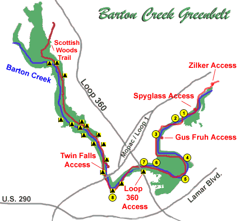
With over 12 miles in all to explore, the Barton Creek Greenbelt offers a variety of recreational activities and stunning natural beauty. Visitors can hike through scenic trails, swim and wade in refreshing swimming holes, or bike along the rugged terrain renowned for its limestone cliffs. The greenbelt is divided into two sections, Lower and Upper.
The Barton Creek Greenbelt is aptly named after the creek it follows, Barton Creek. Visitors can enter at either end or through seven access points in between. Along the trail, you will find sheer limestone cliff walls, lush vegetation, and popular swimming areas. Austin’s subtropical climate allows for year-round use. This greenbelt weighs heavy with traffic on weekends.
Barton Creek Greenbelt is a very popular open space in Austin that is 7.9 miles long with 809 acres and begins at Zilker Park. There are sheer limestone cliff walls, dense lush vegetation, and popular swimming areas.
Barton Creek Greenbelt is one of the most accessible and popular destination for athletes, tourists and fans of the outdoors in Austin. The easiest access point is the Loop 360 access with gently sloping cutback trails so that everyone can enjoy the trail. Of course, it packs more than just a simple hiking trail – visitors can choose between all sorts of outdoor activities. It is popular among bikers, rock climbers, and even swimmers. It is also ideal for bouldering, or even as a leisure spot if you feel like spending some time near the Barton Creek. Regardless if you choose the pristine swimming holes or the marvelous limestone bluffs, you are guaranteed to have a great experience.
Entry passes to the Barton Creek Greenbelt are required and can be purchased via the Apple App Store, Google Play, or at kiosks located at entrances.
The Barton Creek Greenbelt has over 12 miles of hiking trails, and visitors can use one of the many access points to start their journey. While the Upper Greenbelt is more solitary, you might want to stick to the Lower Greenbelt if you are looking for more entertainment. The Barton Creek Greenbelt map tells you just about everything you need to know about the points of interest in the area, as well as where to head if you are looking for hiking, climbing, swimming, or mountain biking.
Lower Greenbelt
The Lower Greenbelt starts from the Zilker Park and ends at the Loop 360 Access Point. In total, you can enter it either via the latter access point, or through Spyglass Access, Gus Fruh Access, and Zilker Access. If is the most accessible part of the Barton Creek Greenbelt if you are coming from downtown. Unsurprisingly, it is also one of the favorite starting points for newcomers.
Bring water, take a trip to the restroom before heading off, and make sure your dog is on a leash if you are bringing it along. Depending on the route you take, your hike through the Lower Greenbelt will be about 7.5 miles.
The Lower Greenbelt is especially popular among climbers as it hosts some of the best cliffs to practice this sport/hobby. Alongside the path of the Lower Greenbelt, you will find some of the area’s most notable climbing spots – read more about them in one of this article’s next sections.
This section of the Barton Creek Greenbelt map also includes some of the most popular access points to the trail:
- Zilker Access – (see map below) From I-35 exit on Riverside and head west. Drive 1.5 miles to Barton Creek Rd and turn left (west). Drive one mile past the Lamar intersection and the Zilker Park entrance will be on your left. The Zilker trail access will be west of the Zilker Pool. Use this entrance if you are planning on riding a bike or if you need to lose a few more pounds.
- Spyglass Access – (see map above) From Mopac/Loop 1 exit on Barton Skyway and head east. Barton Skyway will dead end in less than half a mile. The trail begins where the road ends. Use this access to reach the New Wall/Great Wall. This access can be used to access Gus Fruh
- Gus Fruh Access – (see map below) From I-35 exit on Riverside and head west. Drive 1.5 miles to Barton Creek Rd and turn left (west). Drive about one mile past the Lamar intersection and turn left on Robert E Lee Rd. Take the first right on Barton Hills Dr. Continue down Barton Hills for exactly 2 miles. The access is in the middle of residential neighborhood on the right near the intersection of Barton Hills Dr. and Horseshoe Bend Cove. Use this access to climb at Gus Fruh and Urban Assault
- Loop 360 Access – (see below) From I-35 head west on Ben White Blvd. Ben White Blvd will become 360 (a.k.a. Capitol of Texas Highway). After Ben White Blvd becomes 360 the road will head down a steep hill. This will be approximately 1/4 mile from Mopac/Loop 1. Turn right at the light on the steep hill and turn into the bank parking lot. The trail access will be located at west side of the bank parking lot. Use this access to climb at Seismic Wall and Bee Hive Wall.
Upper Greenbelt
The Upper Greenbelt is known for its favored swimming holes, but they might not be available year-round. During periods of limited rainfall, the Upper Greenbelt swimming holes dry up.
In this part of the Barton Creek Greenbelt, there is plenty of space to walk your dog, lay out a picnic, and enjoy Hill Country beauty. This hike is uneven with ascending and descending terrain. The Upper Greenbelt hike is the place to go if you are looking for natural lushness in the Austin area.
Alongside the main hiking trail, you will find short paths that will take you even deeper into the oak and juniper woods of the Barton Creek Trail. No other trail can match its appeal within Austin city limits.
Barton Creek Greenbelt Things to Do
Barton Creek Wilderness Park
The Barton Creek Wilderness Park is one of the largest in the Austin area. It is an ideal place to seek your next day trip to explore the nature of the Texas Hill Country. In addition to hiking, the “wilderness” of the Barton Creek Wilderness Park accommodates mountain biking, bird watching, and waterfall activity, especially at Sculpture Falls and Twin Falls.
Near Sculpture Falls, you will discover one of the most enjoyable trails belonging to the Barton Creek Greenbelt—the Sculpture Falls Loop. It takes you on a 4.2-mile trip to feel the elevation of about 600 feet full of wonderment.
Barton Springs Pool
The Barton Springs Pool spans three acres and is fed by underground springs, while its waters maintain a consistent temperature range of 68 to 70 degrees—ideal for year-round swimming. The parking lots fill up early near the Zilker Park trailhead in Zilker Park.
Campbell’s Hole
Visitors can access Campbell’s Hole, a less crowded swimming spot, from two points:
- Spyglass Drive to the west.
- 2010 Homedale Dr. to the east.
Campbell’s Hole sees fewer visitors than Barton Springs Pool. Its limited parking lot is within a residential neighborhood. You can also reach this scenic swimming hole by hiking from the Trail’s Head access to the east or Gus Fruh to the west.
Gus Fruh
Parking is limited at Gus Fruh, also in a residential neighborhood. This access takes a 1.4-mile hike from the main access point off the Capital of Texas Highway. Bountiful rainfall fills this swimming hole deep or it is a wader in dry times. This is where the “Urban Assault,” cliff resides.
2642 Barton Hills Drive.
Hill of Life & Trail’s End
The Trail’s End access point is favored by mountain bikers and trail runners at the far end of the Barton Creek Greenbelt. There you find the notorious Hill of Life. It is the Greenbelt’s steepest section. Adventurers can reach Sculpture Falls hiking west to east, or take the Twin Falls entry to the falls from east to west.
710 Camp Craft Road.
Twin Falls
The Twin Falls access point is 1.25 miles from Twin Falls and popular. You hike downhill along Barton Creek and pass a steep rock wall with forested terrain. Water levels in the creek vary and depend on rainfall activity.
3918 S. MoPac Expressway/Loop 1.
Violet Crown Trail
The Violet Crown Trail, one of Austin’s newest additions, follows the Barton Creek Greenbelt from Zilker Park to the 360 Access Point before continuing into the Gaines Creek Greenbelt, just southwest of the Twin Falls trailhead.
This trail extends southwest through the Gaines Creek area to the Circle C Ranch and to the southernmost trailhead at Slaughter Lane. The Violet Crown Trail is under development and slated to extend another 30 miles beyond the Lady Bird Johnson Wildflower Center, Zilker, the 360, and the 290 trailheads.
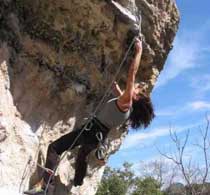
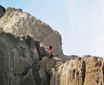
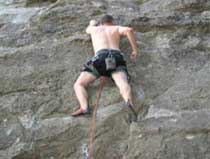
Barton Creek Rock Climbing
Look to the lower part of the Barton Creek Greenbelt for climbing experiences. Spring is the best time to visit when Barton Creek is experiencing high water flow. These climbs are always an outstanding experience in any season.
Beehive Wall: At about one-half mile under the Loop 360 access point, this climb offers twelve routes to explore. You may encounter plenty of traffic at this location during the winter months.
Enclave: Tucked away in a little pocket en route to New Wall—this is a great diversion for an afternoon climb.
Five Eight Sanctuary: 1/4-mile upstream of Seismic Wall on the same side of the creek.
Gus Fruh: Gus Fruh Trail is an access trail from Barton Hills Drive down to the main Barton Creek Greenbelt Trail. It boasts easy access to several climbing walls and a deep swimming hole when the water is flowing.
Kirk \ Alvin’s Wall & Airman’s Cave: Park at 360 access and walk north downstream along Barton Creek, pass Airman’s Cave and look for this wall on the eastern right-hand bank.
New Wall / Great Wall: Next to Terrace: To access New Wall, take the exit for Barton Skyway, turn left across MoPac and head downhill. Locate parking near the “T” intersection. Grab your gear and cross over the guardrail. Turn right at the creek. Go about one-half mile. This takes you to the New Wall, Great Wall, and Random Walls.
Seismic Wall: Find the Barton Creek Greenbelt sign and enter there. Walk down to the creek, and the wall is directly across the usually dry creek.
Urban Assault: Urban Assault is a big white buttress on the west side of the creek with a steep face and big roof.
Barton Creek Greenbelt Map
One of the primary reasons for the Barton Creek Greenbelt’s popularity is how close it is to downtown – few other cities in America can offer such an experience. Unfortunately, because of its impressive size and location, it can sometimes be a bit confusing for people who have not been there previously. One of the most important things to remember about the Barton Creek Greenbelt map is the access points that you can use to get started on your trip, or to find a restroom and dispose of your trash.
Talking of trash and restrooms, here are some of the important tips that you must remember before exploring Barton Creek Greenbelt for the first time.
- There is no problem taking your dog alongside. However, you must remember that they should be on a leash at all times.
- You need to be prepared for the hiking trail. You will not find any water fountains, garbage cans, or restrooms alongside the trails. These are only available at the access points that we will talk about in a bit.
You need to plan accordingly and be ready to carry your trash until you reach one of the access points where you will be able to dispose of it.
Now that these important details are out of the question, let’s see how the Barton Creek Greenbelt map looks. The area can be separated in three separate areas – Lower Greenbelt, Upper Greenbelt, and the Barton Creek Wilderness Park. All of them are reachable through different access points, and they have various great experiences to offer.
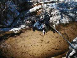
Photos of the Barton Creek Greenbelt
If you are still contemplating whether to visit the seventh best hiking trail in Texas, then here are some more reasons why you should do this. Check out these great photos of the area, displaying some of the marvelous swimming areas, climbing walls, mountain bike trails and, of course, the marvelous waterfalls.
For the best possible experience, we advise you to schedule you visit for the spring – during this period the creek tends to be a bit more full. Of course, rest assured that visiting during other periods will make for an awesome experience as well – you just might not discover all of the beauties that the Barton Creek Greenbelt has in store for you.
Author: Kendall Davis
Author: Kendall Davis Company: Lumini Services Kendall currently lives on the shores of Lake Texoma in Texas. She traveled across two-thirds of the U.S. for many years camping at lakes, rivers, and three oceans before motels and hotels if at all possible, and she continuously saw God's presence in nature. Writing for Lakehub allows Kendall to share her experience with God's creations. https://kdavis1836.wixsite.com/luminiwrites